SPUNCH event - 26/07 - Spaxton

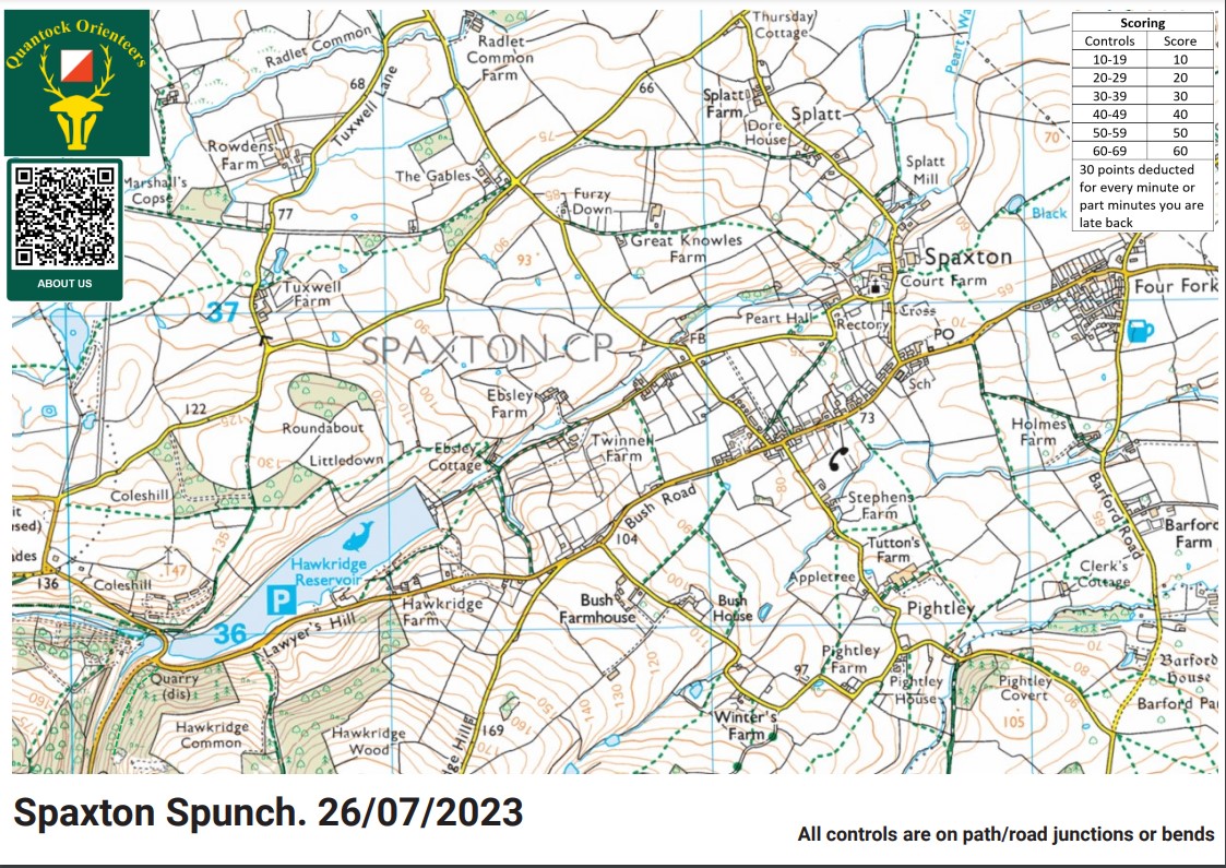
A special urban race designed to bridge the gap between runners and orienteers. A score course using MapRun using an Ordnance Survey base map with a mass start from Spaxton Village Hall.

And They Are Off Senior Mass Start

What’s SPUNCH?

Spunch is a concept devised by Andy Thornton of MDOC, designed to bridge the gap between runners and orienteers. Study’s have shown that one of the biggest blockers to runners participating in an orienteering event is the unfamiliarity with the map, and SPUNCH deals with this by using an Ordnance Survey basemap.

SPUNCH uses the app ‘MapRun’, which is essentially a GPS orienteering app. Turn up your volume and when you run through a control point, you get a satisfying ‘ping’. The events are based around rural villages with high footpath density and the courses are set over a variety of lanes and public rights of way. Spunch typically uses areas not usually associated with Orienteering (i.e. not open access) which gives more regular orienteers a new place to run, and it gives newcomers to the sport a chance to explore some new areas, whilst still being within the relative safety and familiarity of lanes and footpaths.

Course Information

Courses: Long (90mins) and Short (60mins)

Both courses use the same map, with the same number of available controls (checkpoints). The route you take between them is completely up to you!

The score is denoted by the ten digit on the control. I.e. 42 = 40 points. 18 = 10 points.

The aim is to get the highest score in your alloted time.

You will lose 30 points for every 1 minute you go over the time limit!

Please download the app ‘Maprun 6’ prior to arriving and download your respective course. Pin numbers will be provided on arrival to the course area.

Entry Details

Costs: £5 per adult.

£3 for students / 16-20yr olds

Under 16s go free when running with an adult. Under 16s cannot run unaccompanied due to the occasional presence of cars in the course area.

Registration & Start Times

Spaxton village hall car park. Mass start at 7pm.

Contacts / Officials

Planner: Ollie Rant

Controller: Robin Fieldhouse


Here’s a blank map of the area being used for the event so you know what to expect. Control points will be placed throughout the area shown. The controls that are a little trickier on the navigation front, or require more running, will score higher.

3 Likes

Looking forward to it @Mr_Rant :slight_smile:

Now that I’m warm and dry, can reflect on the race, great shame about the heavy rain.
An excellent location, lots of good paths to follow, plenty of route choices and all in a fairly small area. Nice to do a Maprun in a rural area rather than in the streets, but I found the GPS signal didn’t work well under wet tree cover.
I can boost my modest score by claiming 2 more controls that didn’t ping - 65 and 30.
Lesson for me is make sure the app is working before starting! Didn’t realise until I got to my first control - spent a few minutes fiddling with the settings.
Well done Ollie & Robin. Lets do it again and hope for better weather next time!

1 Like

I’ve been through and finalised the scores, now published on the event webpage. I have added points where controls clearly failed to punch. And removed points where crossing an OOB area gave an advantage.

One thing that may cause contention - the website for the event and the MapRun programming files detailed the Victoria scoring system (20 points per control less 10 for every minute over) but this thread and the map detailed the Queensland scoring system (decade points less 30 for every minute over). Hopefully this didn’t make too much of a difference in people’s route choices.

1 Like

Unlike Richard I enjoyed the fact that it was wet and cool, not too slippery either. I enjoyed it so much that I wish that I had gone for the 90 minute choice - but if it had been warmer then I wouldn’t have made it.
The twisty roads around Pightley I found very confusing but that was my own fault for losing my place on the map and thinking I was on a similar bend. With the phone on my arm I had no easy way to check for the control last visited so ended up retracing my steps to pinpoint my location. The map just held out for my 60 minutes but I’m sure it would have struggled for another 30.
Thanks Ollie and Robin it worked out really well and on a sunny evening I’m sure we would have sat around discussing our routes. Maybe at the next SPUNCH?

2 Likes